

Croaghaun [Cruachan]
Good walks are even better shared.
F5506 : Cairn at Croaghaun summit, Achill Island
Colin Park Photo source
Overview
Croaghaun [Cruachan]
Croaghaun on western Achill Island is 690 m in the current DoBIH record. Its natural summit is a rock 8 m southwest of the cairn at F5595406088. The May 2026 revision, based on a new EastWest map, supersedes the older 688 m figure. Summit elevation should not be treated as a measurement of a single vertical cliff.
Lough Acorrymore circuit
GetLostMountaineering describes a 7 km, about 4-hour circuit including the separate southwest top. Start at the road-end car park at Lough Acorrymore, cross the dam, head north and climb west onto the upper slopes. Follow rising ground southwest to Croaghaun, then continue southwest across the intervening low point to the subsidiary top. Retrace towards the main hill, traverse below its summit to the southeast flank, descend east to the road near the car park and return to the same start.
The route involves steep grass, faint paths, rough ground and exposed cliff-rim terrain. Keep well back from cliffs and gullies; strong wind or mist can make route-finding unsafe. These figures do not describe a summit-only return, a Keem/Achill Head viewpoint walk or a traverse to Slievemore. The southwest top is separately listed as Marcach; its older 664 m description must not be used for Croaghaun’s main summit.
Landscape and access
NPWS identifies quartzite at Croaghaun, within the varied metamorphic terrain of Achill’s north coast. The area forms part of the Croaghaun/Slievemore Special Area of Conservation; protect its heath, bog and rocky habitats.
Irish upland access often depends on landowner goodwill. Park without blocking gates or the road, follow local advice, and avoid disturbance to grazing animals. Mountaineering Ireland advises leaving dogs at home for most upland farmland. No current site-specific closure or direct bus to this road-end start was verified on 18 October 2026; that is not a guarantee of unrestricted access. Arrange transport, supplies and a safe return before starting.
Sources checked: 18 October 2026.
Explore routes near Croaghaun [Cruachan]
Walks starting near this hill. Open a route to check its map, distance and full itinerary.
Route planning notes
These notes describe possible approaches. Check a route's map and access information when planning your walk.
Croaghaun and southwest top from Lough Acorrymore
Start and finish at the road-end car park at Lough Acorrymore. Cross the dam and head roughly north on a faint path, then climb west up steep grass to the upper cliff-rim area and follow rising ground southwest to Croaghaun’s main summit. Continue southwest past the steep gully on the right and over the intervening low point to the separate southwest top. Retrace towards Croaghaun, then follow the source’s traverse below its summit onto the southeast flank; descend east over mixed grass and stones to the road near the car park and return along it to the start. GetLostMountaineering gives 7 km and about 4 hours for this complete two-summit circuit. The cliff-rim section needs a safe setback and confident navigation.
Make a day of it, together
Find someone to share the walk with, or organise a day out along a route you like.
Photo Gallery
View all Photo could not load
F5506 : Cairn at Croaghaun summit, Achill Island
Colin Park
 Photo could not load
F5506 : Croaghaun
Mick Garratt
Hill facts and local notes
Classifications
Elevation
690m
2,264 ft
Prominence
690m
Coordinates
53.9840, -10.1966
F559060
OS Map
22 30
At the Summit
Natural summit rock 8 m southwest of the cairn, at F5595406088; the cairn itself is not the recorded highpoint.
Terrain & Geology
NPWS identifies quartzite at Croaghaun. Geological Survey Ireland describes the wider Achill north coast as a varied Dalradian metamorphic succession, including psammite, schist and quartzite. The former granite/volcanic description is incorrect.
Views & Scenery
Atlantic coastal scenery and the western Achill landscape, including the corrie-lake area around Lough Acorrymore, when visibility allows.
Getting There & Facilities
Parking
Road-end parking at Lough Acorrymore, reached by the turn off the road beyond Dooagh, is the start and finish of the documented circuit. Do not obstruct the road or gates.
Public Transport
No direct scheduled service to the Lough Acorrymore road-end start was verified. Check current Achill services and arrange the additional connection and return before travelling.
Nearby Facilities
No staffed facilities were verified at the mountain start. Bring food and water and check village services before setting out.
Safety Information
Known Hazards
- Very high, locally unstable cliffs and steep gullies: keep well back from edges and do not use cliff edges as a navigation handrail in mist.
- The documented circuit crosses steep, rough and partly pathless ground; it is unsuitable as an easy coastal stroll.
- Strong wind, rain and low cloud can make the upper ground hazardous; be prepared to turn back.
- The southwest top is a separate summit; Keem/Achill Head cliff walks and Slievemore traverses are different outings.
General Safety Tips
- Check weather conditions before setting out
- Carry appropriate clothing and equipment
- Let someone know your planned route
- Take a map, compass, and GPS device
- Carry emergency supplies: food, water, first aid kit, torch
Hills
Some common questions about the hills answered
Are there group walks up Croaghaun [Cruachan]?
Many walkers use Walkmates to join or organise walks with others. You can check for group walks around Croaghaun [Cruachan] through the maps
Are there other walkers around Croaghaun [Cruachan]?
Activity varies by location and time, but Walkmates lets you see whether others have shared walks or shown interest in this area. Find other people through the walking friends search walking friends for Croaghaun [Cruachan] search or of course create your own walk for Croaghaun [Cruachan]
Can I organise a walk to Croaghaun [Cruachan]?
Yes. If there aren’t any walks listed already, you can create a walk and make it available for others to join.
If you're signed up to Walkmates, you can create a walk to Croaghaun [Cruachan].
How do I find a walk up this hill?
There are often multiple ways to walk this hill, depending on experience and route preference. Walkmates helps you explore walks and routes that others have shared.
Can I suggest a new route up Croaghaun [Cruachan]?
Yes. You can suggest or create routes to share with others. Walkmates focuses on the social side of walking, so routes are used to help people organise walks and explore areas together, rather than as detailed navigation tools or route libraries.
Other uses really appreciate knowledgeable walkers sharing their routes. Share your favourite route to Croaghaun [Cruachan] here
The is an error or something incorrect about this hill. How do I let you know?
We always strive to keep the information on Walkmates as accurate as possible. If you find an error, please let us know through the contact form and we'll aim to correct it as quickly as possible
Community Discussion
Comments
Location
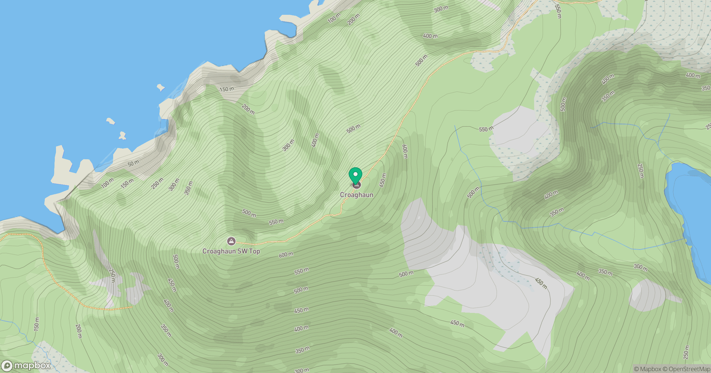
Grid reference: F559060
View on OpenStreetMapOpens a map in a new tab, centred on the hill.
No comments yet. Be the first.